I was itching for another Glass House Mountain adventure. We have nailed a few of the Glass House Mountains of late, so it is starting to be slim pickings with only a few to go, so we decided that Mt Tunbubudla was to be our next challenge.
Mt Tunbubudla is actually two mountains; East and West. They are also know as ‘The Twins’… or ‘the breasts’ (haha) of the Glass House Mountains. They do not have a designated track so I had to do a bit of research to find out what might be the best approach.
I might take the opportunity here to say that some people write some crap directions! Out of all the directions I managed to find, not one of the mentioned that the main access track that they accessed the mountains with was a serious 4WD track – and I mean serious, so it is just as well we were not in the family sedan, and even then the directions were sketchy at best. I can see how people get lost in the bush.
Anyway, I am going to give you some good easy directions, and ones where you will be able to take the family sedan, though the road is unsealed, but it is traversable without a 4WD.
So depending on where you are, find your way to Beerburrum. It is a little town on the Sunshine Coast just off Steve Irwin Way.
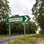
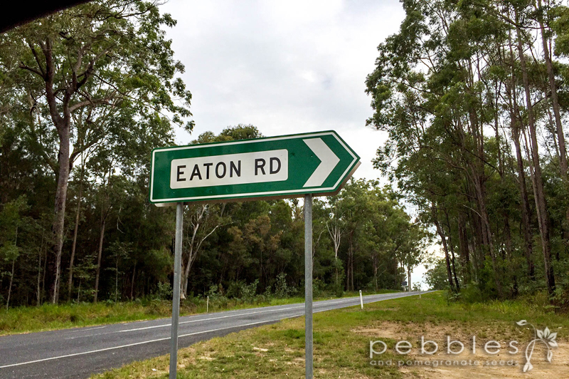
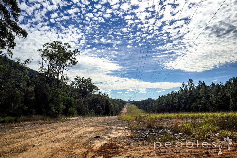
The best access point is via Eatons Road which is a few hundred meters south off Beerburrum Road. If you are coming from Beerburrum heading towards Caboolture, it is on your right. Follow this unsealed road down to its very end – about 2km. You will come to a cleared section with powerlines running through it. Park by the powerlines, there is plenty of room. The access path to the saddle of the two mountains is directly at the end of Eaton’s Road – you will see the gate with a National Park’s sign.
It’s walking from here along the dirt bike tracks that run through the park and follow the path to the saddle between the two mountains. It curves around a bit, but you can see the two mounts, so it is easy to see that you are on course. When it gets to the end, it branches into two directions, if you are climbing via the saddle, then veer to the right and it will lead you there. There are several access routes from either side of the two mounts. The path we took takes you to the middle of the peaks, at which point you can climb whichever you choose… or both.

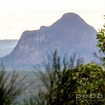
We decided to do both. I had read that while East Tunbubudla is a little taller at 312metres, it is West Tunbubudla (293metres) that has the better views. So to ensure the second climb didn’t end as an anticlimax we opted to do East first and savour West last.

The entire round trip, from the car and back and up both mounts is 7.85km and took us just on 4 hours. I am sure a fit climber can run rings around our time; we stopped for photos, snacks, admiring the view, huffing and puffing, and my occasional expletive, so it was a very loose 4 hours.
Mt Tunbubudla East isn’t a difficult climb, but it isn’t the easiest either. There are red ribbons tied on trees as markers to lead you up to the summit, and there is a little bit of a path, but it is not overly obvious. There are a few difficult patches where the rocks are quite loose, which makes the path a bit of a scramble in places. Having said this we found it more of an issue coming down than going up.

There is a pile of rocks marking the summit, which became our snack spot. My cherry babe had carried the backpack with the goodies again, so happy days. I was hungry too!
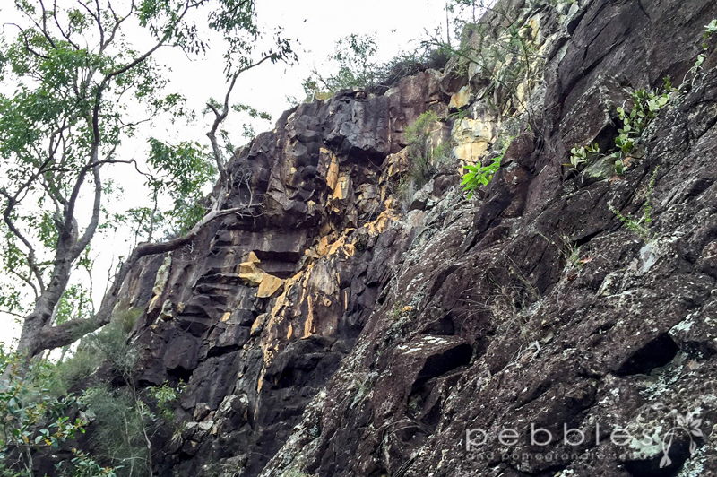
There are great views in various positions on the accent, but the views are obscured by the shrubbery, so while it was still an awesome view it wasn’t the spectacle it could have been. What was good about it was that you could appreciate Mt Tunbubudla West and the fabulous rock face halfway up the mount.
I thought the trip down would be quick and easy but it was incredibly slippery, so we really had to watch our footing… and give each other a bit of space… having your feet swept from underneath you from behind is not an entirely pleasant experience… just sayin’. The markers were a little bit more useful going down as well. The East mount took us just under 2 hours, but that was really taking it easy.
When you get to the bottom you just keep walking on the path towards your right and it leads up the West mount. There are no markers, just a bit of a rubbly path. You will see the rockface, so just head directly towards it. There is a ‘pimply tree’ which is a good point to take note of – you will find it more useful when coming back down as it helps direct you to the path down, as it all is a bit disorientating on the way back.

When you reach the rock face you can either head left or right. I read that the left involves a bit of a climb, and while usually I would be up for it, it was a warm day, and I was feeling a little fatigued so decided that there was no need to make the second climb more difficult than it needed to be, and headed to the right of the rock face and followed it closely, climbing the perimeter of the face to reach the top. From there, there are a few random red markers on trees that help lead the rest of the way to the West summit.
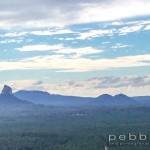
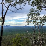
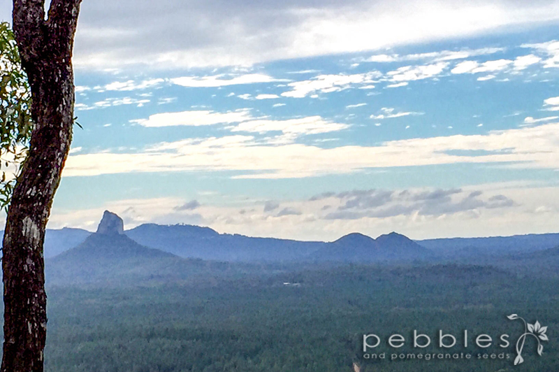
Yaayyy… and there was another little pile of rocks to greet us at the top. The views are best just on top of the rock face – the shrubbery is a bit more open and you can look out to Mt Beerwah, Mt Coonowrin, Mt Ngungun, Mt Tibrogargan and Mt Tibberoowuccum – which is pretty spectacular.

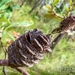
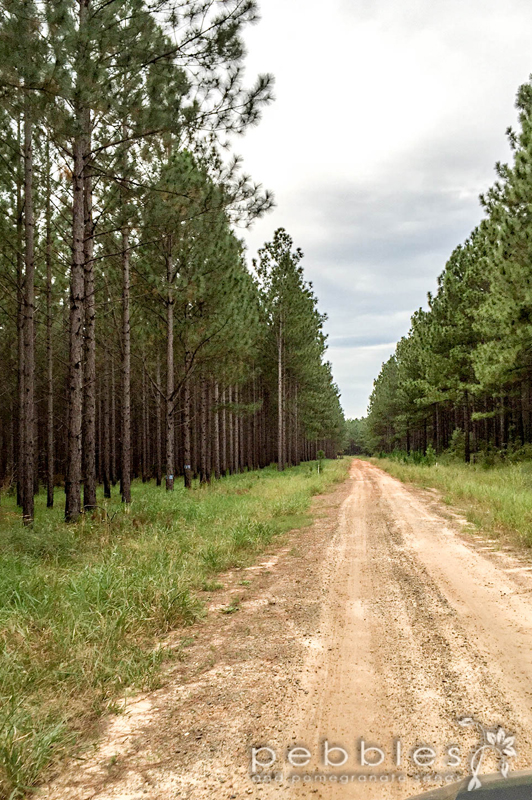
I have climbed a few of the Glass House Mountains now, and I never tire of the views. Every summit comes with a different aspect and yet another arrangement of surrounding mountains. The landscape is so varied; pine trees, native forest and huge scars of red earth running in between dividing up the land. It was a shame that the day had clouded over – when we started out, the skies were a beautiful blue with dappled clouds which cast a wonderful clarity over the mountains, but it clouded over as the day went on and there was a bit of a smoke haze as well. The native forest is pretty spectacular too, some great old gnarled trees – a story or two to tell I am sure, and there were some beautiful little purple native flowers *squeal* which speckled the undergrowth, which was otherwise laden with Xanthorrhoeas and gums. I have identified them as a Native Iris or Patersonia – I might become a botanist yet 🙂

I noticed on the way down there were a few white markers on trees, which I think led down the other side of the rock face (an adventure for next time). And remember, look out for the pimply tree as your cue to start walking down the hill.

Such a great walk. It is a big walk, and you do need to be prepared with plenty of water. The climb is not difficult by any stretch of the imagination, but you do have to have a degree of fitness, and then at best it is challenging.
The walk back to the car is quite refreshing. It was intriguing to me that the track was so sandy. The track is quite etched out, from the dirt bikes I would say, and there were a few around, so it doesn’t hurt to look over your shoulder every now and then if it sounds like they are close… because sometimes they are!
I would also avoid doing the climb when it is wet as we could see that the tracks very quickly turn to clay. It was slippery as it was, no need to add wet into the mix.
On the way out we took a different road, which is how we found the Eatons Road entry point. The track we initially came in on was a carved out old access road – The Old Gympie Road – so if you are accessing from there, you will need a 4WD, unless you plan to walk from the road, and walk the East mount from an alternative access track.
Definitely a great climb and well worth it. Looking forward to exploring the rock face on another day.
So that’s ‘the boobies’ done, next…
This story was written by Petra Frieser – Pebbles + Pomegranate Seeds